Overview
The Oregon Extreme Precipitation application provides precipitation-frequency, temporal-distribution, report, and basin-attribute information for Oregon dam-safety and water-resources work.
The app was developed by WEST Consultants, Inc. on behalf of and in cooperation with the Oregon Water Resources Department.
Current Capabilities
- Explore preprocessed precipitation return levels for existing Oregon basins.
- View observed storm temporal-distribution information from rain gauges.
- Open pre-generated precipitation, basin-attribute, and guidance reports where available.
- Create an authenticated profile and submit user-defined point or polygon workflow jobs.
- Track completed, partial, failed, and running jobs from the User Jobs tab.
Coming Soon
- Representative storm downloads for temporal and spatial distribution workflows.
- Additional PMP and hydrologic-guidance material.
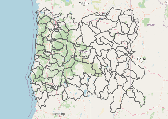
Users interested in precipitation information within the domain shown below may find this tool useful.
Using the App
The Analysis page contains the interactive workspace.
Explore
Use the Explore tab to select public datasets from the map, view plots and tables, download selected tabular results, and open available pre-generated reports.
Open the Explore tab
Data Creator
Logged-in users can define an area of interest by latitude/longitude or uploaded geospatial data, then request precipitation-frequency and/or basin-attribute workflows when the input geometry is valid for the requested products.
Open the Data Creator tab
User Jobs
Authenticated users can review submitted workflows, refresh job status, and open available report or geospatial-output links after processing completes. Partial jobs may still show successful outputs from completed branches.
Methods
Existing basin results combine point and areal precipitation-frequency estimates, storm-duration and seasonal structure, climate-change correction information, and supporting basin attributes.
- Basins under 10 mi2 use point-based precipitation-frequency estimates.
- Basins over 10 mi2 use areal estimates from Max-Stable Process models.
- Climate-change adjustments compare projected and historical extreme precipitation estimates.
- Basin attributes summarize land cover, snowmelt, snow-water equivalent, fire, and soil datasets.
Outputs should be reviewed with engineering judgment and the supporting report context.
Future Features
- Additional PMP and hydrologic-guidance material.
- Representative storm downloads for temporal and spatial distribution workflows.
Contact
Benjamin Choat, PhD, PE, WEST Consultants, Inc.
Email: bchoat@westconsultants.com